A major cold front decreased temperatures allowing precipitation to fall as snow above 6,000 to 7,000 feet rather than as rain to bring an end to this unusual June Atmospheric River event. Unfortunately, our neighbors and friends to our east in the Greater Yellowstone area and Red Lodge area received higher rainfall amounts that combined with snowmelt to produce historic runoff amounts primarily on the eastside of the continental divide. Our thoughts are with you as continue to dig out and rebuild.
Temperatures, in Idaho’s west-central mountains at SNOTEL sites like Jackson Peak at 7,070 feet, reached highs of 60-65F for several days prior to June 11 and above freezing nighttime temperatures allowed the snowpack to melt 24/7. On June 11, the temperature reached 63F at 2pm and gradually decreased to 32F by 3AM Monday morning June 13. Sunday Jackson Peak received 1.5 inches of total precipitation as temperatures played a critical role allowing the precipitation to change from rain to snow in the higher elevations. These near freezing temperatures also slowed the snow melt that was feeding the streams prior to the storm. Temperatures remained in the 30s until noon Tuesday, June 14.
Monday morning, we headed north, packed the Subaru and dog (got 35.5 mpg traveling 870 miles in two days). You could see the new snow from Tamarack Resort to the Seven Devils range and in the Selway-Bitterroot mountains on Tuesday. What a beautiful site with green valleys below.
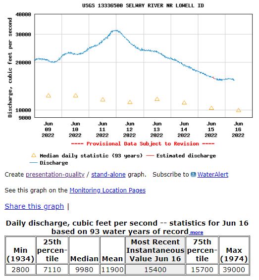
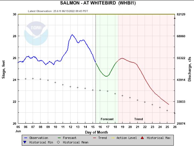
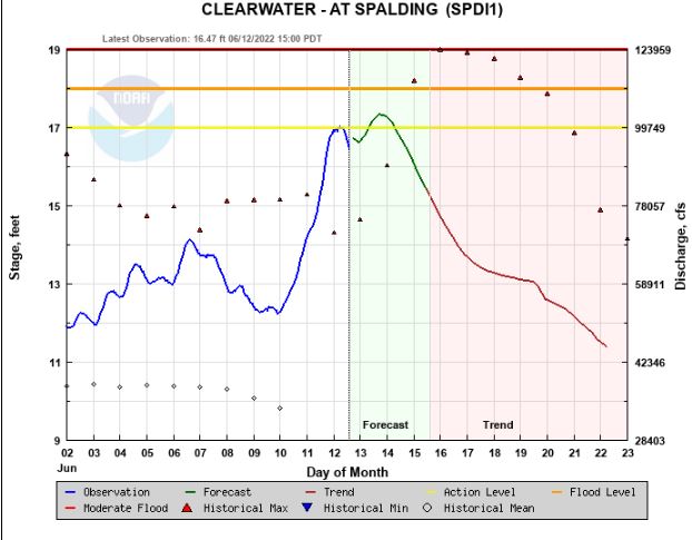
These freezing night temperatures slowed the melt as rain subsided forcing streams to peak lower and recede earlier than streamflow models were trending. Rain turned to snow to melt later which will help extend recession flows. This is good news as many were running bankfull and approaching record flows for this time of the year in the Clearwater basin.
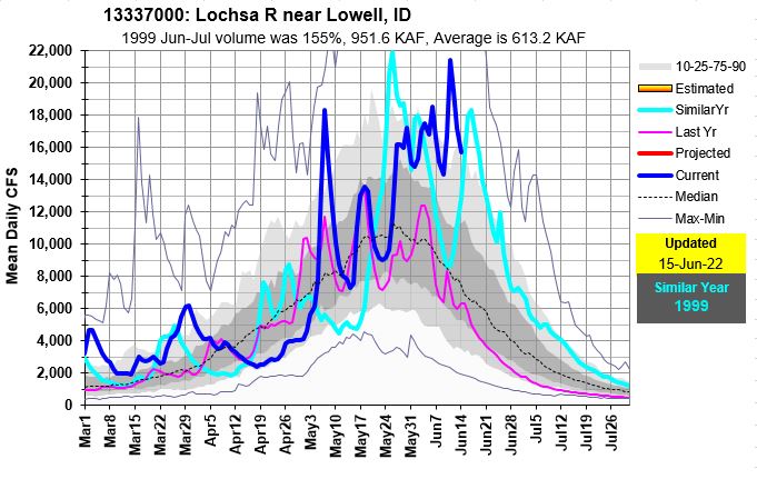
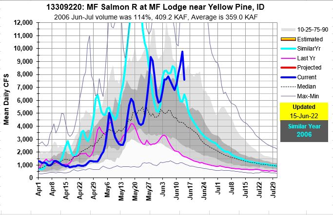
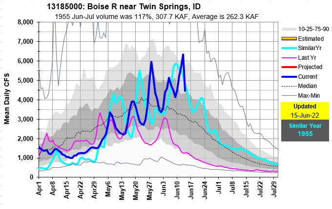
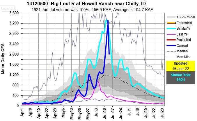
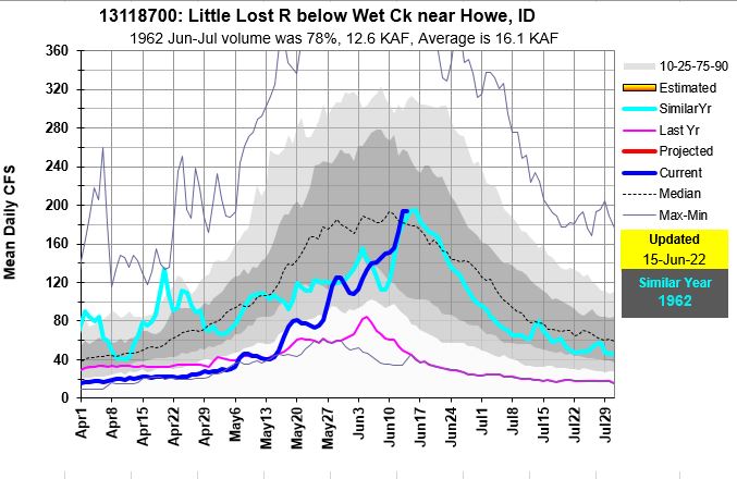
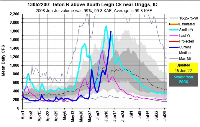
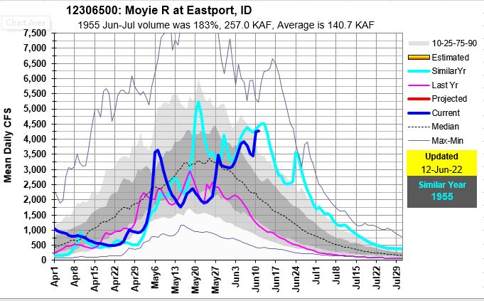
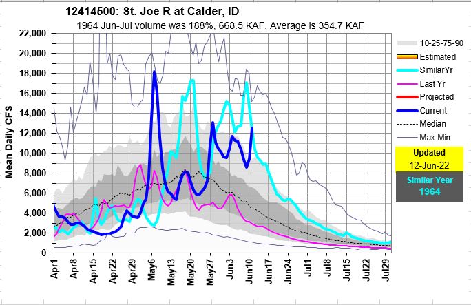
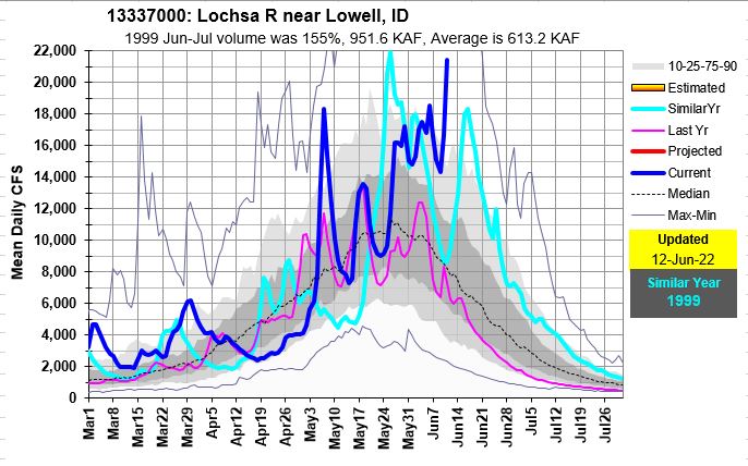
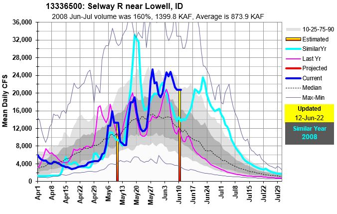
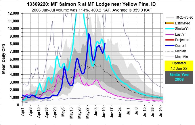
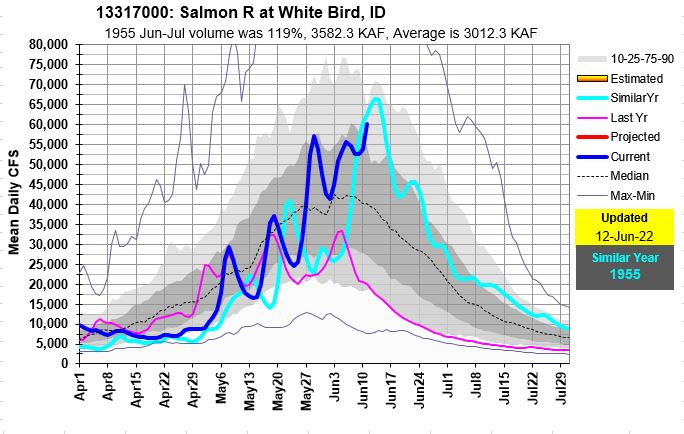
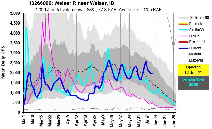
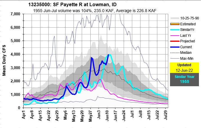
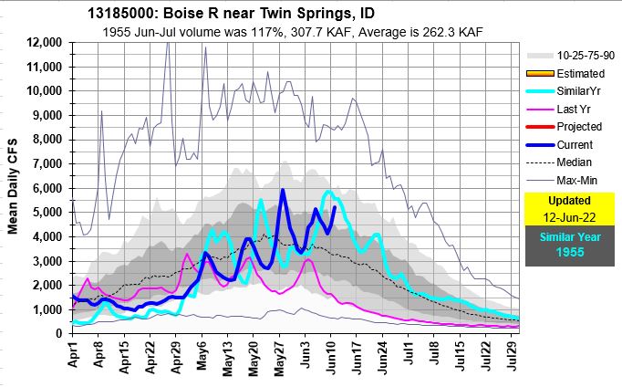
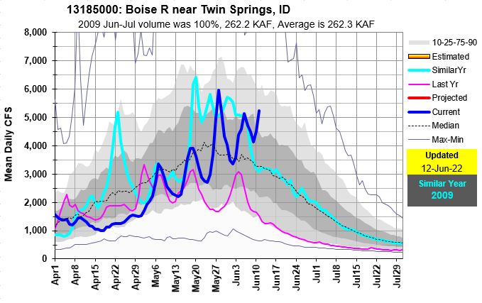
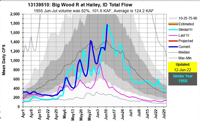
Following are current flow graphs showing this year, last year and similar year based on current flow. I included the Wood and Lost rivers, our next road trip that starts today. Who’s in or wants to talk rivers in the Ketchum area this weekend?
Also included is Alan Smith, an OpenSnow Jackson Hole meteorologist, and his excellent summary of the super cell storm that quickly developed over YNP. https://opensnow.com/dailysnow/jacksonhole/post/26668
And post by Cliff Mass about why thunderstorms develop over mountainous areas. Cliff is from Seattle and his long range PNW temperature forecasts were right on for this area too. Not sure who to reach out to about Idaho tornadoes because we don’t have many. https://cliffmass.blogspot.com/2022/06/why-do-thunderstorm-prefer-mountains.html
Be safe as rivers are still running high and flowing fast with swift currents and strong eddies that are fun to watch from a distance. Rivers are bankfull with steep drops into the cold water. Know your river running limits if you are putting on the river. If you are a fair weather floatier, I’ve seen two forecasts that says warm, dry, hot weather will arrive for the last 10 days of June. Be safe and enjoy another cool, wet weekend!