A winter Atmospheric River in June !

What an event it was that added much needed moisture to many Idaho rivers. Following is a statewide summary about the impacts of this early June Atmospheric River Event. This rain on snow event increased streamflow in many rivers across the state that will push recession flows out a bit.

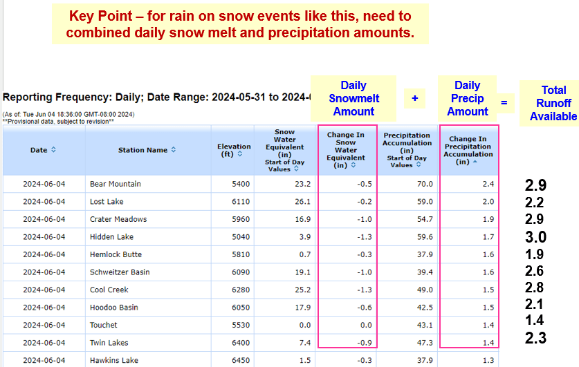
Combining daily rainfall and snowmelt resulted in 2.5 to 3.0” of Total Runoff Available at a few SNOTEL sites. The cool May temps delayed snowmelt allowing snow to remain in higher elevations that provided a runoff boost with the falling rain. 

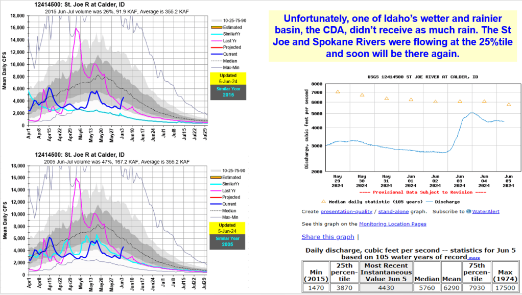
What a storm it was – who do you thank ? Those benefiting include fish, wildlife, river runners, salmon flows, hydropower production and more. The streamflow boost created another flow increase that will keep recession flows higher longer. However, some basins missed the positive impacts from this event. See the following analysis to see why some rivers benefited while others continued with their downward recession trend.

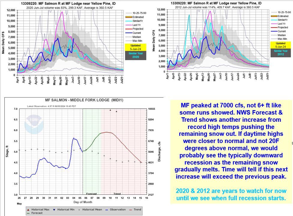
Benefits include assisting with final fill of some reservoirs, delayed irrigation water use that may even result in better reservoir carryover storage for next year. Impacts include challenges for those on rapid rising rivers especially for those adventuring on the MF Salmon River and experiencing the New Velvet Rapid up close.

Interesting Weather on the Way…

Now this is gonna get interesting… who remembers what the meaning of life is – from hitchhikers guide to the galaxy ?  42 and this is also Boise’s Magic temp for snow to be falling at Bogus, for most storms. Let’s Keep It Simple Silly (KISS) so we don’t have to explain the adiabatic temp lapse rate decreasing 3F /1000 ft increase in elevation. 

The NWS forecasts for Boise for Tues shows temps pushing 43 F and Bogus at 34 with rain snow mix and snow line / level around 6,600 ft !!! Elevation matters and makes a difference! Stay tuned and let’s hope the snow on ground and frozen soils can keep the temps cooler than the models are predicting and snow keeps falling above 6,000 ft !!!

In Idaho, rain-on-snow runoff events happen below 5,000 ft from mid-Nov to mid-Feb. We’re step-up nicely for rapid runoff if the rain intensity and duration occurs because of valley snow cover and frozen soils. Soils in my backyard are frozen deeper than my shovel can easily dig. What’s happening in your backyard ?

It’s always interesting to watch these storms set up as they cross the Pacific, the ocean swells they produce and becomes an Atmospheric River when they hit the west coast and move inland.  

Get ready to enjoy the ride from this AR ! Be safe whether you’re deep in snow on a mountain side as avalanche danger will increase from this heavy snowfall on the colder lighter older snow layers OR if you’re watching the creeks and rivers rise in the valley bottoms! How high the rivers rise depends on duration / intensity of rain and temps above 32F.

The good news from OpenSnow mentions the weather door in PNW may remain open in early Jan to start the New Year !!!

Above NWS hourly temp and precip outlook for my Boise house and for Bogus below.

Ocean swells tracking across Pacific as it brings in next week’s AR.
https://magicseaweed.com/North-Pacific-Surf-Chart/80/?type=swell

7-day total precipitation for Dec 24-31. And OpenSnow outlook for start of the new year. Happy New Year 2023 !!!