
An AR is moving in and that doesn’t stand for Abramovich.Ron but is a major June Atmospheric River precipitation event. 1-2” of precipitation is predicted with snow on the highest peaks in the west-central mountains. Rivers will rise next week!
Time for a road trip next week to check out the flows, who’s in?
Many SNOTEL sites in central Idaho just melted out. The ones that still have snow are losing 1-2” of SWE a day! This means there is 1-2” of water melting out of these high snow fields. This and recent rains were enough to keep river flows up and allow them to drop yet. This weekend, 1-2” of moisture is predicted across many of these ripe basins.
This is where it gets interesting – the Boise basin has already received 75% of its normal June precipitation in the first 9 days of June – enjoy the green foothills and morel hunting.
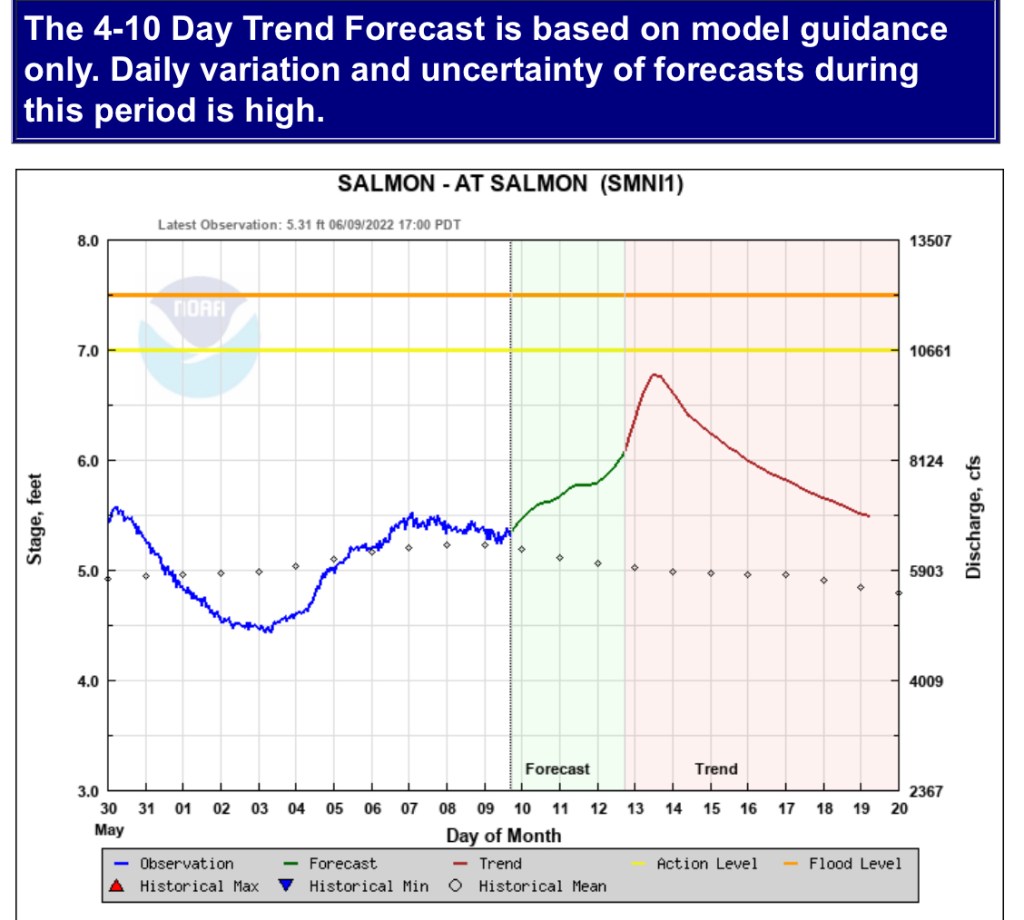
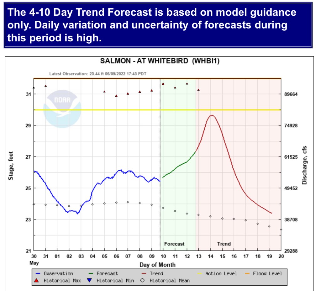
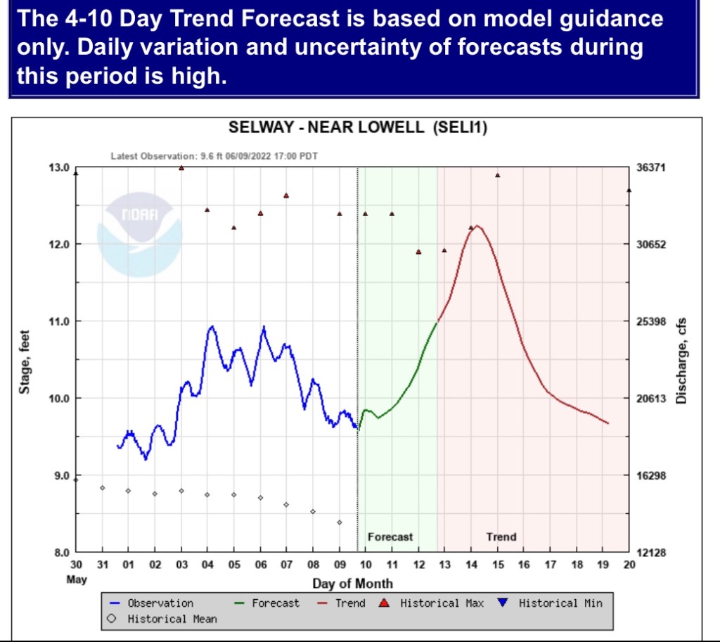
There is no need to talk about the Snow to Flow relationships at this point. These work best to determine when the snowmelt peak may occur verse the absolute peaks (the highest seasonal peak flow). Believe me, we’ve had many fun discussions about the difference of these peaks and how to best predict them. Next week’s peaks will be rain influenced and higher than the previous peak. The Snow to Flow Relationships are telling us how recent the snow peak occurred, how much snow remains to feed the streams, and which rivers have not peaked yet, like the Teton River.
Rain peak typically rise faster and receded fast than snowmelt peaks, the remaining higher elevation snow will sustain flows. This is best explained in Idaho Power’s operation summary and duration of high flows.
The Brownlee Reservoir 3-day average inflow is currently 24,000 cfs, and the Hells Canyon Dam 3-day average outflow is 21,000 cfs. The current weather forecast for the Payette River and surrounding basins show significant precipitation for this weekend. This expected precipitation has significantly increased the inflow forecast for Brownlee Reservoir which is near full pool. Idaho Power will be increasing discharge below Hells Canyon Dam this afternoon and those increases could persist for the next two weeks. Boaters below Hells Canyon Dam can expect flows to range from 15,000 cfs to 30,000 cfs. Boaters should remember that actual operations are subject to change due to system reliability, and they are encouraged to be aware of changing river conditions.
Natural flow for the Boise River today is 7,728 cfs into Lucky Peak while the Boise Reservoir System is 86% full; the Payette system is 93% full. https://www.usbr.gov/pn/hydromet/boipaytea.html
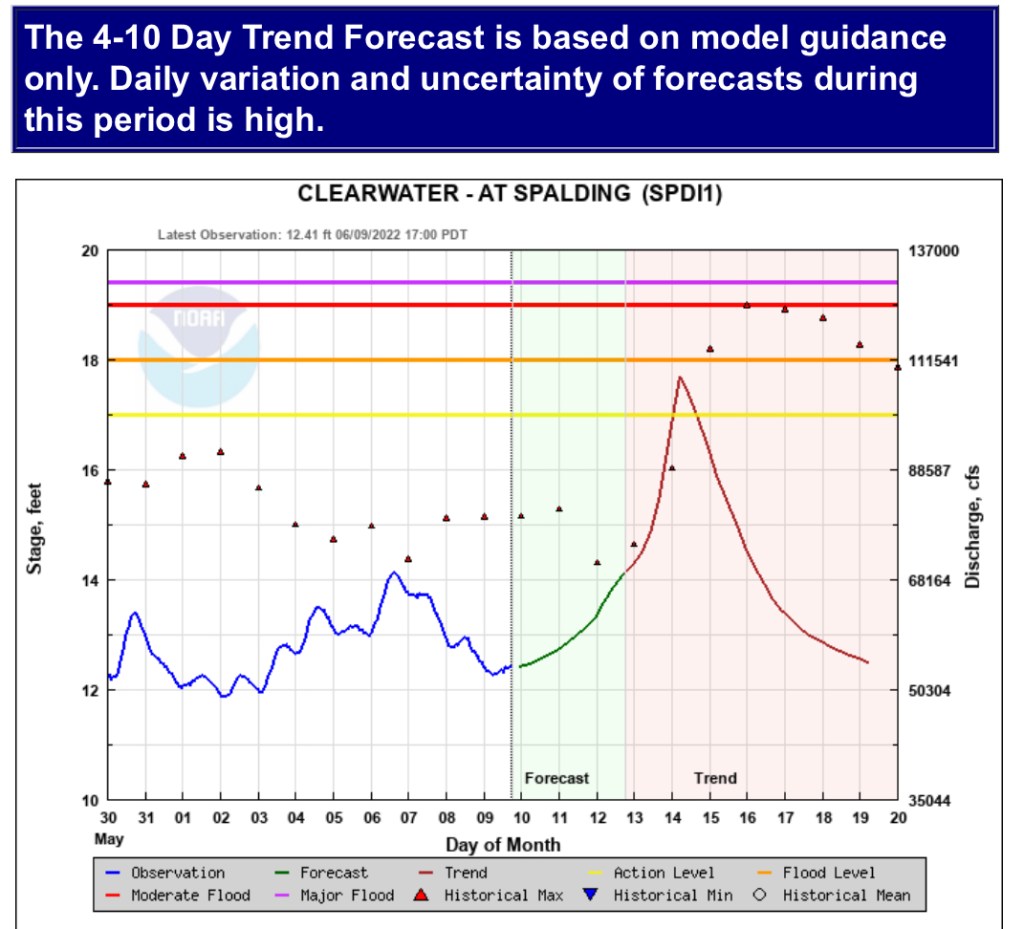
Here are NWS river flow projections. Stay safe, know your limits or enjoy our amazing rivers from a distance.


Thanks, Ron! Next week I’m playing music at Weiser, but late June/early July I’m really hoping to get some river time….
Just FYI, here in Australia it’s almost all rain-dominated, with very short flashy high flows. It takes some getting used to…. The ground where I am is pretty saturated from a wetter-than-average May, so the ephemeral creeks are running at the moment. But winter is the dry season, so while it’s expected to be wetter than normal, I’m expecting the local creeks to wind down, some already have.
It hasn’t rained now for over a week, very sunny, but cold (for Australia). I’m looking forward to Idaho summer!
Cheers,
Lisa
Sent from my iPad
>
LikeLike
I still have a lot to learn about the land down under. I enjoy learning from you! Need to get down there sometime, we were going to for our honeymoon, but went to Blanchard ID with my family instead! We’ve been talking about biking the Weiser bike trail when the river is flowing, now is the time. If we make it to Weiser, I’ll find you, otherwise yes, end of June rivers should be nice for floating. I have two rafts in garage if need one…
A co-worker, headed to Australia, like 15 yrs ago to help solve your drought. Tom Pagano was sharp, he developed this USGS analysis spreadsheet hat just keeps working and has the best summary analysis plots I’ve seen. That is why I can keep analyzing the flow so easily. But my own blog wont let me post a Weiser flow pic. I’ll try another way…
LikeLike