Strong or weak La Nina, it doesn’t really matter for years following a strong El Nino like last year. Years that follow seem to have a lot of energy to release, as mentioned in last post. Keep in mind, the key Pacific months to watch that correlate with our winter snowfall and spring/summer streamflow are July-November, and we have only seen the data thus far through September for this year.
Here’s a few examples to watch as winter moves in to set the Dinner Table. Nothing can be guaranteed but with wild weather around us, there is no reason not to expect the extreme and wild weather to continue. We are not living in the calm and quiet doldrum years like the early 2000s.
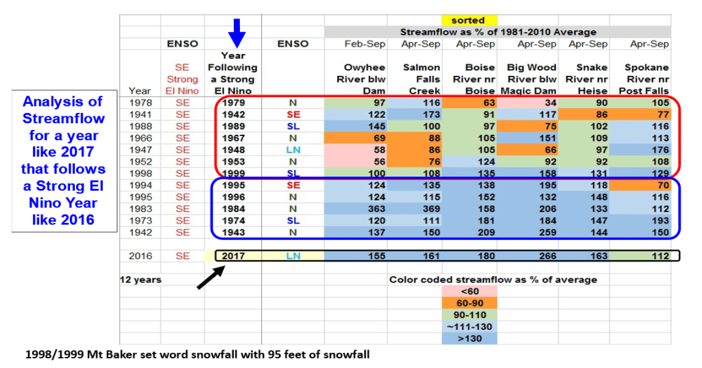
Following are highlights:
- NOAA’s mid-September Prediction shows the likelihood of a weak or mild La Nina and one outlier favoring the strong.
- Usually, we don’t start looking or talking about the Siberian snow cover until November, but it’s off to a great start!
- Another source to explain the Siberian Snow Cover relationship is from Severe Weather Europe, if you can read between the ads.
- Now let’s look at Pete Parson Oct 17, 2024, analog years update for this season.
- 1967 – doesn’t stand out as it was a near normal year in central Idaho.
- 1993 – a near normal year sandwiched between two drought years, 1992 & 1994, that was influenced by the 1991 Mt Pinatubo eruption.
- 2017 – a huge winter with 45 Atmospheric Rivers hitting the West coast.