Mid-December Snow Update and Comparison to Analog Years

Now with snow starting to accumulate in the mountains, let’s look at the start of this winter’s snowpack and compare it to the analog years we’ve been talking about. Here’s a recap of Pete Parsons, Oregon Dept of Ag, Seasonal Climate Forecast from November 21, 2024 Update.

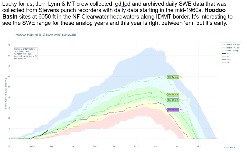
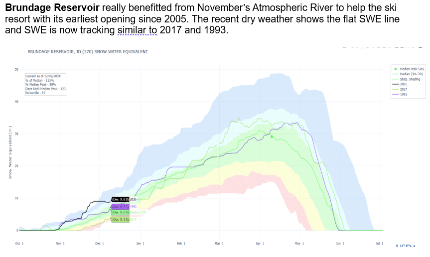
Let’s have some fun and look at how this year’s snowpack is starting to accumulate and compare with the analog years 1967, 1993 and 2017. We’ll look for similar snow accumulations patterns and as we progress deeper into winter, we’ll see if one year stands out more than the others and use it to provide some insight about next summer’s river flows.

Early Bird Forecasts and Analog Year Summary

Early Bird Forecasts or are they called Outlooks – either way, you got to know when to hold them, know when to believe them, know when to walk away and know which areas are favored for more snow and why. There are lots of late summer/early fall Winter Outlooks being shared and passed around. Recently, it seems there is a race to see who releases the first Outlook. Here’s a summary about what I’ve been watching for a while. See if it helps or share what you watch and works for you. Don’t believe the first forecast you hear or until you hear the same forecast from 2 or 3 unrelated friends.

Read on for more info about SOI correlation with western rivers and how analog years are identified and used to help with predicting / monitoring this winter.

Analog years used for this winter (water years):

1956-57 is water year 1958

1964-65 is water year 1966

1971-72 is water year 1973

Another analysis shows this year’s El Nino initially was tracking 2009-10 El Nino winter. Next post: SWE plots of analog years and 2010 to how snow is tracking or not.

Review of La Nina Analog Years from June 2023

Keep in mind, Pete’s analog years are based on current Pacific Ocean and atmosphere conditions to generate awareness of current conditions and precipitation and temperatures outlooks based on
analog years. They were never intended to zoom down to a basin level or individual station, but let’s have some fun, give it a try to see how they worked to give us a heads up about the winter snowpack for Twin Lakes SNOTEL, Boise Basin and Bogus Basin SNOTEL.

How did we get here…

Here’s a long PDF talk explaining 2022 snowfall and runoff compared to analog year 2009. This provides the background to better understand Pete Parson’s 2023 analog years. These current analog years are 2000, 2009 (again), & 2012 and runner up years of 1957 & 1972. January 15, marks the half way point of winter. A return to stormier and cooler PNW is predicted next week, which is great and unlike last year! Time will tell if we track one of these analog years or not. And if a late snowmelt as observed in the analog years occurs as winter ends and flows into spring. Spring melts away as rivers increase. Stay tuned and enjoy the ride…

Keep your eye on the horizon and let’s hope the storms continue building snowpacks across Idaho in the 2nd half of winter!!!